


The ultimate app for Geography/Geology amateurs and professionals."
- Mel Martin, TUAW.com
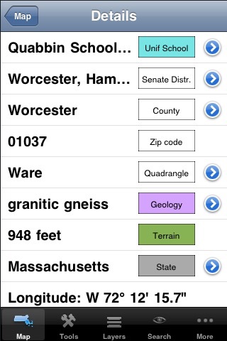
Do you know which state assembly district you are in? Which school district? Where is the closest railroad? Is there a mine nearby? What kind of rock are you sitting on?
Geograph MA is the edition of the popular GIS (geographic information system) covering the commonwealth of Massachusetts. It is a self-contained application (no Internet or cellular access required) that contains a vast amount of information about the geography and geology of the Bay State. You can combine various data layers, zoom in and out, and get a lot of details about the physical and human geography of Massachusetts.
While this is a professional-grade tool, it can easily be used by anyone curious about their environment.
This release contains over 45 layers (new layers are frequently added). Installed by default are:
- states outlines
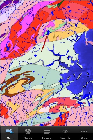
- the complete geological map from USGS
- surficial materials and faults
- terrain elevation and bathymetry
- zip codes
- over 4,600 named features (summits, tunnels, cliffs, bridges, etc...) with link to USGS information page
- U.S. congressional districts with link to representatives web sites
- over 1,100 mineral resources with link to USGS web site
- active mines
- public land ownership
- hydrologic units
- EPA ecological regions
- USGS quadrangles
- urban areas
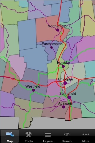
- counties with link to census data
- hydrology
- roads and major streets
- railroad tracks
- cities and towns with link to census data
- UTM zones
- main aquifers with link to EPA web site
Layers that can be downloaded from the application include:
- state House districts with link to representatives web sites
- state Senate districts with link to senators web sites
- elementary, secondary and unified school districts
- boundaries of cities and villages with link to census data
- town boundaries
- landmark areas (parks, campgrounds, airports, etc...)
- landmark points (schools, hospitals, fire stations, etc...)
- airports with link to FAA data pages for each airport
- areas of critical environmental concern with link to detail page for each site
- geodetic points with link to the National Geodetic Survey details pages
- national park boundaries with link to the National Park Service web page for each park
- waterways and ports from the U.S. Army Corps of Engineers
- railroad crossings with link to details page from the Federal Railroad Administration
- detailed surface geology for some parts of the state
- boat/fishing access
- long-distance bicycle trails
- natural communities
- FEMA flood zones (premium content)
Each layer contains additional information about its features. For instance, the geology layer has a description of the units name, age range, rock type, and description. Each mine has a name, a commodity, a facility type, and a company name. See our web site for more information about each layer. Layers can be re-ordered and combined with transparency, allowing an unlimited number of combinations.